
Jessica Brunacini, training and engagement director of the Wells National Estuarine Research Reserve, described how residents of Maine’s Drakes Island and Moody Beach used the Photovoice technique to explore and share their deep connections to those places.
A photograph can show what a coastal place looks like. Photovoice goes one step further by helping people explain why that place matters to them.
Rhode Island Sea Grant and the Narragansett Bay National Estuarine Research Reserve recently hosted a webinar about using Photovoice in coastal communities.
Alexie Rudman of the Institute at Brown for Environment and Society and Jessica Brunacini, director of training and engagement at the Wells National Estuarine Research Reserve in Maine shared examples of how people have used photographs, stories, and artwork to talk about changes happening along the coast.
What Is Photovoice?
Photovoice is a way for community members to share their experiences through photographs and short written reflections.
A Photovoice project usually begins with a question. Participants take photographs that answer that question and explain what each image means to them. They then meet as a group to discuss their photographs and find common ideas or concerns.
The photographs and stories may later be shared through a public exhibit. This gives planners, researchers, public officials, and other community members an opportunity to learn from the people who experience these places every day.
“Photovoice really enables community members to bring forth their own interests as opposed to a top-down agenda,” Rudman said.

Artwork created by Jessie, Willa and Sophie, shown from top to bottom, as honorary participants in Shoreline Stories, an expanded Photovoice project focused on the Providence waterfront.
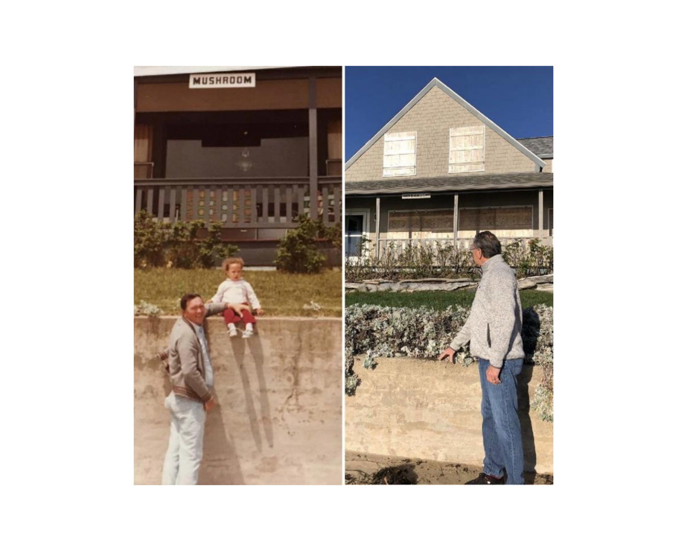
Photographs taken at the same Moody Beach location in 1983 and 2021 show changes in the height of the sand over 38 years. Both men pictured are 6 feet 2 inches tall.

“Julia’s water triptych,” created during Shoreline Stories, an expanded Photovoice project focused on the Providence waterfront. Credit: Julia/Shoreline Stories
Sharing Stories From the Providence Waterfront
Rudman discussed Shoreline Stories, a community project focused on the Providence waterfront.
The project expanded the traditional Photovoice process by allowing participants to use different kinds of art. In addition to photographs, participants created paintings, sculptures, linocut prints, knitted artwork, and pieces that included historical maps.
Participants were asked to think about the Providence shoreline’s past, present, and future. They explored topics such as pollution, coastal access, community history, climate change, and their hopes for the waterfront.
Many coastal plans focus on roads, buildings, other infrastructure, and financial costs. Those plans may not fully show the memories, traditions, cultural connections, and personal experiences that make a place important.
The artwork helped participants share those parts of the waterfront’s story. It also gave them time to think about difficult emotions connected to pollution, environmental injustice, and changes along the shoreline, said Rudman.
The finished work was shared through an in-person community gallery and an online exhibit. This allowed more people to see the waterfront through the experiences of those who live, work, and spend time there.
“The people who live and work and rely on these places are the experts,” Rudman said. “It really drives home the importance of listening to the people who call this home.”
Reflecting on Coastal Change in Maine
Brunacini used Photovoice with residents of Drake’s Island and Moody Beach, two coastal neighborhoods in Wells, Maine. Both communities are vulnerable to flooding and sea-level rise.
She asked participants one question: “When it comes to this place, what do you care about most?”
Brunacini did not tell participants that the project was specifically about climate change. She wanted to see whether concerns about coastal change would come up naturally in their photographs and stories.
Residents photographed beaches, homes, gathering places, and other parts of their communities. Some also used older family photographs to show how the shoreline had changed over time.
The photographs showed how much residents valued the beauty of these places and the memories they had created there. They also showed concerns about flooding, erosion, sea-level rise, and what the communities may look like in the future.
“The process of Photovoice, with its creative approach and its multiple points of engagement, really helped to create time and space for participants to reflect on their lived experience with change,” Brunacini said.
The project ended with a five-week public exhibit at the Wells Reserve. The photographs were also displayed at a coastal-resilience workshop attended by local officials. This brought residents’ experiences into a discussion where their voices might not otherwise have been included.
More Than Photographs
The Photovoice process can also help researchers, planners, and public officials understand concerns that may not appear in maps, computer models, or reports. These may include family memories, cultural connections, access to the water, and feelings about environmental change.
By sharing photographs and stories, community members can help shape conversations about the future of their shoreline. Their experiences can help coastal planning include not only what can be measured, but also what people value and hope to protect.
Join the Coastal Resilience Learning Network
The webinar was part of the Rhode Island Coastal Resilience Learning Network, which connects municipal staff, planners, and coastal practitioners to share information, tools, and strategies for strengthening coastal resilience. To learn more or join the network, contact Rhode Island Sea Grant coastal project manager Eliza Berry at eliza.berry@uri.edu.