A new CoastSnap station at Crescent Beach is giving Block Island residents and visitors the opportunity to help document shoreline change while contributing to ongoing coastal research.
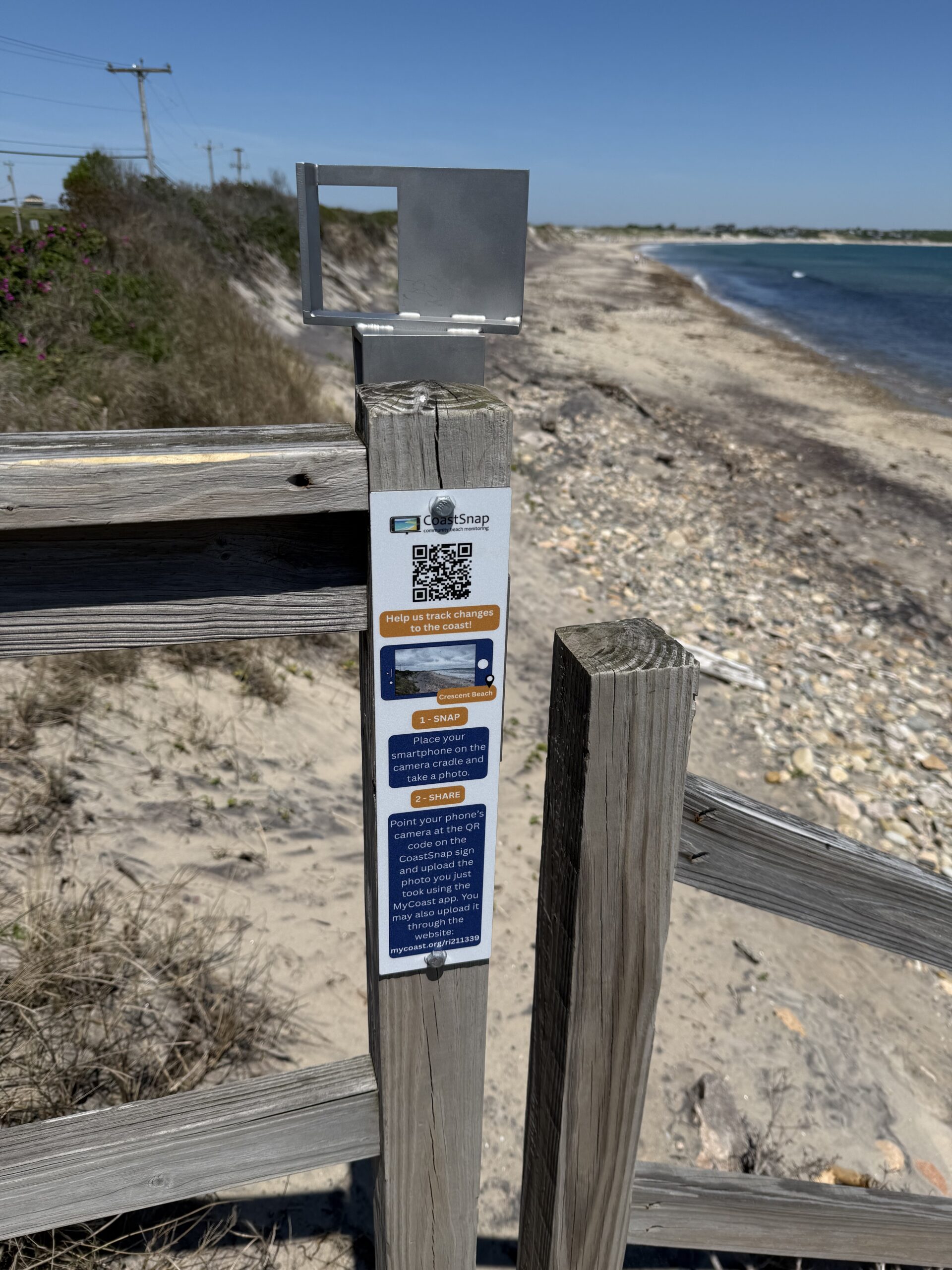
Installed last week by Rhode Island Sea Grant-supported researchers in partnership with the Town of New Shoreham, the station is the first CoastSnap installation on Block Island. Located at the staircase just south of the Crescent Beach pavilion, it allows visitors to photograph the shoreline from a fixed location and upload the images to an online database.
The photographs will help researchers document how the beach and dunes change over time in response to storms, erosion, seasonal conditions, and sea-level rise.
“Crescent Beach is an incredibly dynamic shoreline, with waves, storms, and shifting sands constantly changing the shape of the beach,” said Nathan Vinhateiro, Science Director for the Coastal Institute at the University of Rhode Island and co-investigator on a Sea Grant-supported research project examining shoreline change and coastal resilience on Block Island. “CoastSnap allows anyone with a smartphone to help us document those changes over time and contribute to a better understanding of how this coastline is evolving.”
As part of related Sea Grant-supported research efforts on Block Island, Vinhateiro recently joined Bryan Oakley, professor of Earth System Science at Eastern Connecticut State University, in collecting sediment samples across the beach and dune system to better understand how sand moves through the coastal environment.
Grain size, they said, plays an important role in determining how beaches respond to waves and storms and can help inform future decisions about beach replenishment, dune restoration, and other resilience strategies. They are also investigating why some areas of the shoreline appear to be changing more quickly than others and whether waves, groundwater, or other factors are driving those differences.
“Understanding where sediment comes from, how it moves, and what processes are driving erosion is critical if communities are going to make informed decisions about future resilience efforts,” said Bryan Oakley, professor of Earth System Science at Eastern Connecticut State University and principal investigator on the project.
The CoastSnap images collected by residents and visitors will contribute to a related effort investigating natural and nature-based approaches to reducing coastal erosion and protecting vulnerable infrastructure. The photographs will provide an additional record of shoreline conditions over time, helping researchers evaluate how beaches and dunes respond to storms, seasonal conditions, and sea-level rise while directly engaging the public in the scientific process.
The station is part of the Rhode Island Sea Grant-funded project Combining Monitoring and Numerical Simulations of Natural and Nature-Based Solutions to Coastal Erosion: Block Island, a Numerical Test Site, led by Annette Grilli with co-investigators Eliza Berry, Bryan Oakley, Nate Vinhateiro, Stephan Grilli, and Christopher Baxter.
This is part of Rhode Island Sea Grant’s broader effort to expand community science opportunities throughout the state. Recent enhancements to the CoastSnap network and other monitoring programs are helping residents contribute valuable observations that support resilience planning and coastal management.

Bryan Oakley, professor of Earth System Science at Eastern Connecticut State University, uses GPS surveying equipment near Block Island North Light to measure beach slope and shoreline elevation as part of ongoing research examining coastal erosion, sediment movement, and shoreline change.
Visitors to Crescent Beach are encouraged to stop by the station, take a photo, and help build a long-term record of shoreline change on Block Island, one snapshot at a time.
To learn more about CoastSnap and explore shoreline monitoring sites in Rhode Island and beyond , visit: https://mycoast.org/ri/coastsnap/about

Explore Block Island's Changing Coastline
To learn more about ongoing research examining shoreline erosion, bluff retreat, sediment movement, and coastal resilience on Block Island, explore the interactive Block Island Coastal Change StoryMap developed by researchers and community partners working on the island.
The StoryMap, developed by URI’s Coastal Institute, combines maps, historical imagery, research findings, and visualizations to help residents and visitors better understand the processes shaping Block Island’s coastline and the challenges posed by erosion and sea-level rise. It is one of several resources being developed to support coastal resilience planning and decision-making on Block Island.
–Meredith Haas, Rhode Island Sea Grant