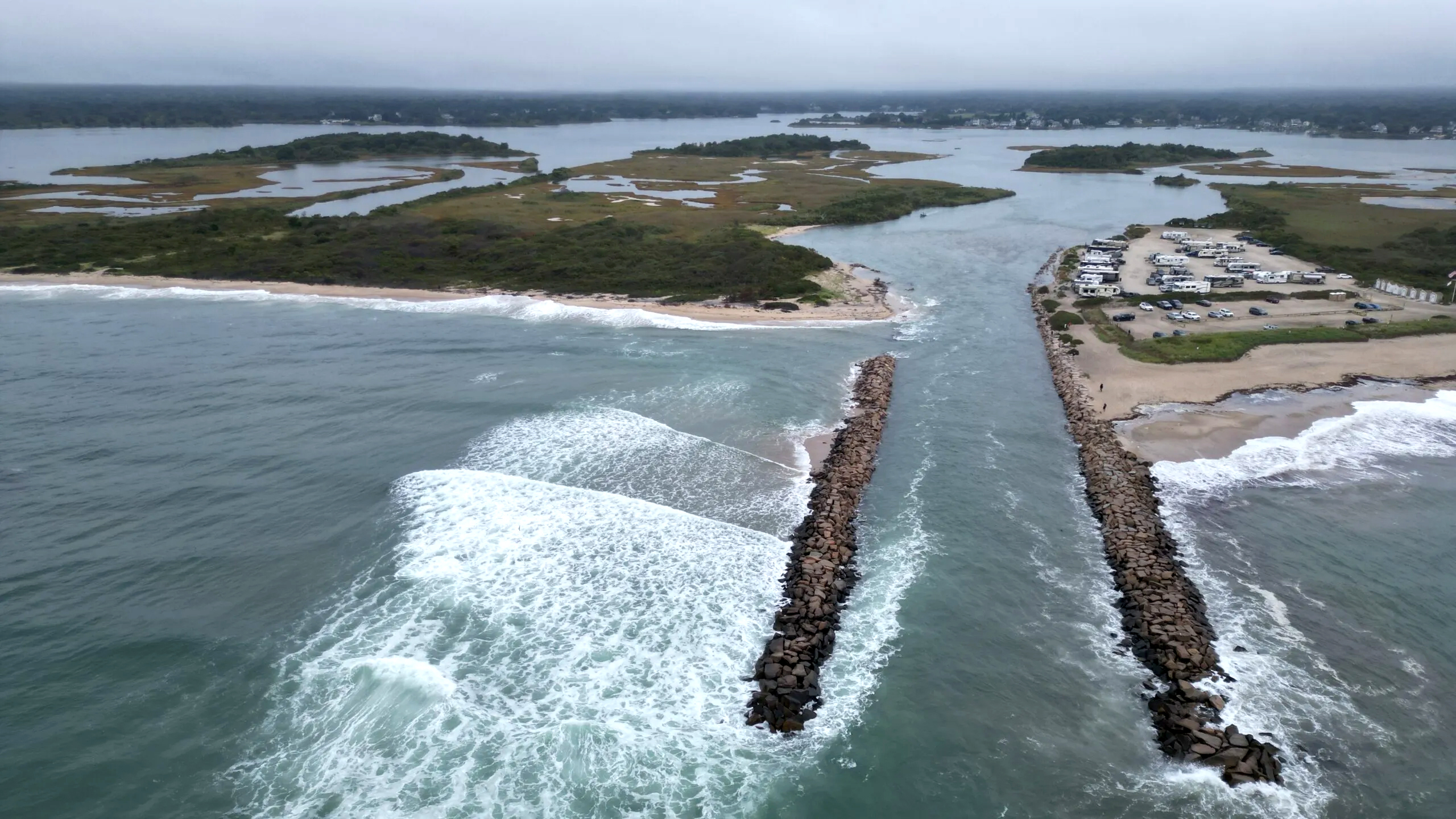
Aerial of Charlestown Breachway during king tide, August 2024. MyCoast photo by Bob Petrone
In southern Rhode Island, a critical piece of coastal infrastructure is in trouble.
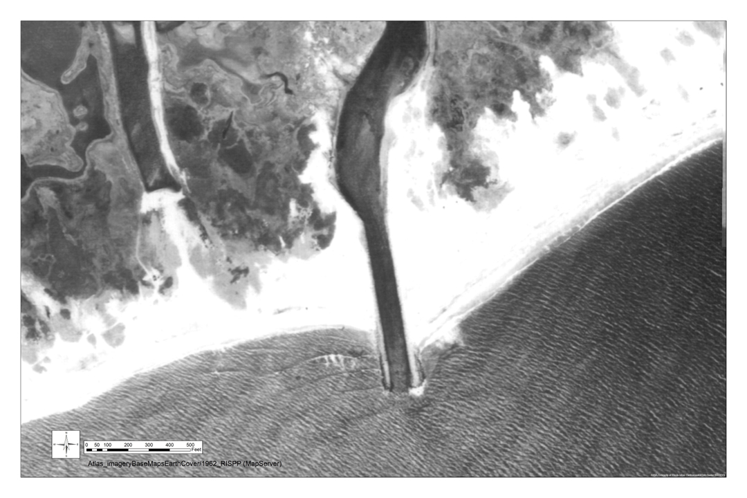
Aerial view of the Charlestown Breachway in 1962, 10 years after it was built.
The Charlestown Breachway is a rock jetty lining the channel connecting Ninigret Pond to Block Island Sound. Conceived of more than a century ago, and completed in 1952, the breachway was built to stabilize the inlet, ensuring the flow of seawater between the pond and the sound to maintain oyster health. Today, the breachway helps maintain critical habitat and is valued for recreational boating and fishing. The east side of the breachway is a state beach and campground, while the west side belongs to the Division of Fish & Wildlife at the Rhode Island Department of Environmental Management.
Unfortunately, in 2012, the breachway was one of Hurricane Sandy’s many victims, bringing significant loss of beach, dunes (a critical piping plover habitat), and the first big breach of the jetty. Intense storms in the last three years rapidly accelerated the damage, particularly to the beach on the west side of the channel, including a complete overwash of the dunes.
Continuing sedimentation from the west side of the breachway into the channel has caused severe safety concerns and made it difficult for boats to navigate the channel. Its boulders have sunk into the sediment, and areas of the structure are “pretty much destroyed at this point,” says Casey Tremper, Coastal Resources Center/Rhode Island Sea Grant (CRC/RISG) climate adaptation specialist, who is part of the effort to plan a long-term solution that fits a variety of human and ecological needs. That multi-year project includes engineering, design, and permitting work through the end of 2025, setting the stage for restoration of both the breachway and the adjacent dune habitat.
Video by Steve McCandless, Charlestown GIS coordinator
Tremper and Pam Rubinoff, another CRC/RISG specialist in climate resilience, have been assisting the town with community engagement for the past few months as part of the first phase of the project. They’ve worked with Emily Diamond, University of Rhode Island assistant professor of communication studies and marine affairs, to gather stakeholder concerns through a series of focus groups and interviews with state agencies, local business owners, fishers, workers, recreational users, and a liaison from the Narragansett Tribe.
URI students assisting with the project recently completed a survey of visitors to the breachway and local residents, gathering their visions for a resilient Charlestown, and identifying how best to keep the community informed and engaged with the project. In August, there was a presentation to the Salt Ponds Coalition on the project by Steve McCandless, the town’s geographic information systems (mapping) coordinator, and Tremper and Rubinoff are helping identify more community partnerships by planning a breachway walk and discussion. Additionally, CRMC is assisting with the permitting process for the project. Funding for this restoration design phase has come from the Rhode Island Infrastructure Bank, along with a grant for modeling work via the National Centers for Coastal Ocean Science.
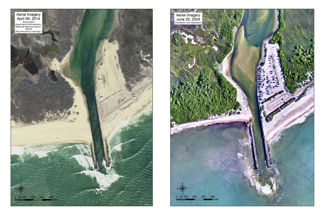
These aerials from 2014 and 2024 show how the breachway has degraded and how siltation at the mouth of the breachway and in Ninigret pond has accrued. Image courtesy of Steve McCandless.
The town, in coordination with the Rhode Island Department of Environmental Management and the Rhode Island Coastal Resources Management Council, is in the process of designing and permitting emergency repairs to the west wall this fall, which will be integrated into the design of the longer term restoration effort.
In 2025, the second phase of the project will kick off with reconstruction of the west wall of the breachway, dredging in Charlestown Pond, and dune restoration. Funding is still in the works, and is expected to consist of a mix of grants and town funds.
Additional video footage of the breachway by Bob Petrone shows the breachway during the king tide of September 18, 2024.
The advisory group for this project includes the U.S. Fish and Wildlife Service, the Rhode Island Department of Environmental Management, the Rhode Island Coastal Resources Management Council, Save The Bay, the Salt Ponds Coalition, and local businesses.
—By Georgia Young, Rhode Island Sea Grant Communications Fellow