
| • Welcome |
| • About Us |
| • Contact Us |
OCEAN SAMP FACT SHEET
Download a copy of the factsheet (pdf). The below fact sheet explains what the Ocean SAMP is and includes a map of the proposed project area.
WHAT IS THE OCEAN SAMP?
The Rhode Island Ocean SAMP, or Ocean Special Area Management Plan, will define use zones for Rhode Island's ocean waters through a research and planning process that integrates the best available science with open public input and involvement.
WHY
Global warming is perhaps the most critical issue of the 21st century. It is already accelerating sea level rise, leading to beach erosion, property losses, and increasing Rhode Island's vulnerability to hurricanes and floods. Climate change may adversely affect food supply, public health, and the economy. Rhode Island is committed to reducing its carbon footprint by using renewable energy resources, primarily offshore wind farms, to meet 15 percent of its energy needs.
From 2008 to 2010, through a public policy process that includes scientific research and stakeholder involvement, the Ocean SAMP will make Rhode Island the first state in the nation to zone its offshore waters for diverse activities including renewable energy development. This process will also protect current uses and habitats through zones for commercial fishing; critical habitats for fish, marine animals, and birds; marine transport; and more.
WHO
Leading this project is the R.I. Coastal Resources Management Council (CRMC), the state's coastal management agency. Among other responsibilities, CRMC is charged with managing the state's submerged lands. CRMC has already zoned Rhode Island's near-shore waters for a variety of uses, from industrial ports to conservation areas.
CRMC is leading the SAMP effort with the support of the University of Rhode Island (URI). Federal agencies such as the Minerals Management Service and the U.S. Army Corps of Engineers, which have authority in federal waters, will participate, as will state agencies including the R.I. Department of Environmental Management.
RESEARCH
Research projects undertaken by URI scientists will provide the essential scientific basis for Ocean SAMP policy development. These projects assess wind speeds, appropriate technologies, marine life, geology, meteorology, and more. Information about each project is available on the Ocean SAMP web site.
STAKEHOLDERS
Public involvement will help shape the policy and is crucial to the success of the Ocean SAMP. All Rhode Islanders are invited to share their insights and concerns about offshore renewable energy and the Ocean SAMP with the project management team through the contact information below.
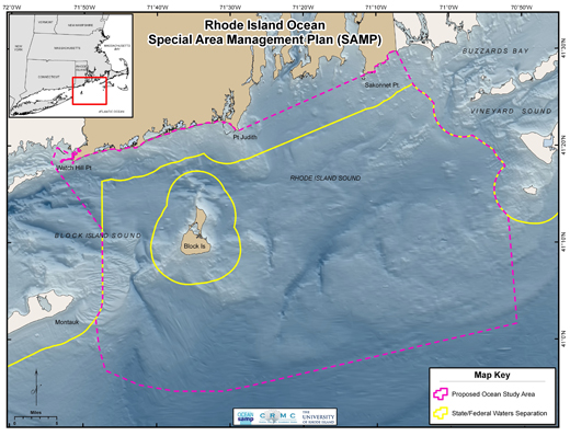
PROPOSED OCEAN SAMP STUDY AREA
State and federal waters within the boundary depicted in the map below, an area of approximately 1,547 square miles (1,168 square nautical miles), are included in the SAMP. Beyond state waters, the SAMP will be developed with federal agencies that have jurisdiction in federal waters.
To ensure that regional impacts to natural resources are appropriately considered in this process (a federal requirement), this planning boundary includes all waters that are less than 150 feet within this described boundary. This boundary may be altered depending on natural and human use considerations. For example, once the commercial and fisheries usage maps have been completed, it may be appropriate to either expand or reduce this boundary.
Proposed Ocean SAMP Study Area Updated August 2009 |
CONTACT
For more information about the project contact Jennifer McCann at (401) 874-6127 or e-mail mccann@gso.uri.edu. For CRMC regulatory questions, contact Laura Ricketson-Dwyer, CRMC public educator and information coordinator, at (401) 783-7886 or e-mail lricketson@crmc.ri.gov.
R.I. Coastal Resources Management Council | University of Rhode Island
